Pequest River by Johnny's Hot Dog
Has anyone seen the white tops of the rocks in the Pequest River by Johnny's? I would like to find out what it is. I have never seen this before.
 Bevbighead
 MK
MK 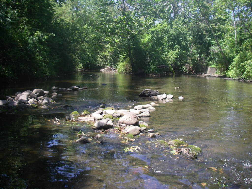
The rocks in the Pequest River near Hotdog Johnnys river have had those white stains for many years.You just noticed?
 Lady Jayne
 My guess is that the tops are white because they are typically exposed to the air and have been bleached by the sun. The reason you notice them now is that portions of the rocks that are not typically exposed are now exposed due to the low water level and they provide contrast that isn't normally there.
 ianimal
  hktownie
 Sorry to tell you that the white on the rocks are not stains, and you can scrape it off. has nothing to do with water level, its on tops of rocks that never get covered by water. I have had three people ask me about this. Thought I would post the ? to see if someone had the answer.
Almost looks like salt or other mineral deposits; I've seen them in the Delaware and the Paulinskill. I was wondering too because I've never seen this before and I know I would have noticed-glad you posted this thread, Bev-I know it's something unusual and I'd like to find out also!
 jams
jams The lower Pequest is heavily influenced by limestone (The Reading Prong s under the whole valley, which is why the hatchery is locate there.) That combined with the salt from winter, and lack of high water to flush it out leads tot here being lots of scale on the rocks. Especially in low water.
 Agust
Agust Agust - The "Reading Prong" is not limestone, but a mixture of gneissic and granitic rocks, which normally leach out their acidity, which could help dissolve the limestone that the Reading Prong intrudes upon and carry it in solution with the spray from the water going past the rock deposits on top of the rock when the water evaporates. The leachate remaining behind as a type of "frosting" if you will.
The gneisses, etc. of the Reading Prong stick out, because the limestone that once "filled in the gaps" between the mountains were created by inland seas via deposition. Since the limestone is much softer than the gneiss, streams and rivers cut through them and eat them away, rather than erode the gneiss which weathers much more slowly.
Further reading on the "Reading Prong":
https://en.wikipedia.org/wiki/Reading_Prong
http://www.dcnr.state.pa.us/topogeo/field/map13/13rps/index.htm
Here's a nice article from "The Journal of Petrology" for all you rock-heads out there (like me - LOL):
http://petrology.oxfordjournals.org/content/15/2/325.abstract
 Phil D.
  CraftBeerBob
 Cool! Know that we know about the rocks, does anyone know what kind of snake that is? Doesn't look like a Garter or Black snake. That is one big ,fat snake.
PS: Congratulations to Villanova and her fans! Great game.
 JBJSKJ
 I thought the white residue was the silica remains from diatoms, a cold water thriving algae.
This is common on the musky as well
doc - I somewhat doubt that, since I haven't heard of any cases of silica deposition like that, whereas carbonate deposition through dissolved and transported solids happens all the time, most commonly in caves and caverns, under bridges, etc as flowstone or other common features. Of course we could go out there with our acetic acid and drop a few droplets on there to test for carbonates;-) I have seen it on the Musky too here and there, but never tested any rocks for carbonates. I'll have to check into it further now, lol!
Not sure about the snake either, though the size and banding does look similar (from what I can see on my little monitor) to an Eastern Mississauga aka "Timber" Rattler, but I'm just giving it a shot in the dark. I don't think it would be a Water Moccasin, since I'm not sure it inhabits that area.
 JL
JL No water moccasins in NJ. That's a plain old water snake... they are non-venomous but nasty little suckers.
 Mark Mc.
 All - Nice to see the geology of the beautiful greater H'town area discussed. I miss the rolling hills of the Jersey highlands.
- from a fellow geologist.
 Georob
 Yeah, I didn't think I'd ever heard of the Water Moccasin any higher than VA, but species are showing up in different areas. Glad Mark Mc. pointed out what it was.
Georob and anyone else interested. There's a rock, mineral, gem and fossil show this weekend in the Edison area (and from what I understand 2 more filling out this month too, including the one in Franklin, NJ, when the Franklin Mineral Museum and the Sterling Hill mine in Ogdensburg will be open as well!
Mark Mc. is right it is a northern water snake. They can grow up to a length of 4 ft
and they are mean !
 Janster
 Why the Pequest is running low:
Limecrest quarries on Limecrest road in Andover pumped their "Big Hole" to mine and while doing so added significant amounts of water to the headwaters. Which start in the "German Flats" west of Sparta. They used the alignment of the road (Limecrest) to allow continued excavation of the main pit. Homes were built off Pinkeville road on a ridge, this blocked future road moving and the residents complained of noise and Silica dust. Limecrests' new owner (Old Castle Concrete Products), declined a fight and shut down the pumping, which resulted in a lower flow in the Pequest.
Thomas Edison opened the Limecrest Quarries
 Hot corner
 Pretty sure the Limecrest Quarry pumping was into the East Branch of the Paulinskill, and the lack of cold water happened a few years back, when we removed the Trout Conservation Regulations on that particular river. The river still flows, but now flows much warmer.
Commenting is no longer available.