Official 2013 Thunderstorm thread
Back by popular demand. Can we top last year's 500+ posts? We will see. There's a chance we could get off to a decent start either tonight or possibly Thurs/Friday.
 Bryan
Bryan  botheredbyu
 I think it's of interest that last year's thread wasn't started until May. We are off to an early start this year.
 Calico696
  Yima
Yima  icicle
  Tracy
Tracy  just saying is all
 It's turned extremely dark near Mountain Lake. Big, chunky very dark clouds. Wind and rain starting.
 Lifeistooshort
 Just walked into my kitchen which faces NW and saw the sky beyond the woods was that eery black. Got the dog out just in time.
 Blackcat
 The lightening display over house was unbelievable. Streaks across the sky all over the place. Anyone else see this? Wow!
 just coach
 Had a t-shower at 4:30 then a pretty big boomer at 6:30. Not a ton of rain but either way it's much needed to stop the brush fires for a while.
We got a ton of rain over about a half hour here. Sky was lit up with lightning like mad. Nice and cool out there now.
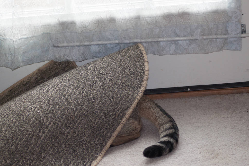
I arrived home with one cat cowering under the table, and the other laughing at scardie cat.
 GC
GC Here in Hackettstown we have had 0.50 inch of rain with numerous lightning and thunder. No hail or wind damage. Temp got to 82F this afternoon and has fallen to 59F with the passage of the storms.
It felt weird driving some of the area roads yesterday before the storms moved in still with some traces of leftover road salt on the road and temps in the low 80's driving with the windows down. LOL
MUCH needed rain yesterday! Bryan I'm hearing another round of heavy rain tomorrow afternoon? Unlike yesterday this one won't be severe.
Hit a very impressive 84 degrees yesterday at the Pequest Fish Hatchery with almost 3/4 of an inch of liquid in the bucket = .73
 Vic
Vic yeh i wound up with about the same amt of rain vic. I haven't followed it too closely but i thought the heavier rain would mostly be Friday.
The strangest thing last night was the thunder rumble. It went on a good 5 minutes without a break! So weird! I can't ever remember that happening before.
 Lady Jayne
 This easterly moving storm actually moved South us, a little scary and close to turing teal but not quite. Lots of air lightning but basically we just caught the Southern edge.
Was surprised that it was not brutal North of 80.
And yes Bryan, Friday rain supposed to be a soaker at 1 inch or so (until they change the forecast....:>)
 mistergoogle
 John C
 Here's a good explanation for a rumble vs a crack. Also explains why a rumble might last a longer time...
http://www.weatherdudes.com/facts_display.php?fact_id=46
So it sounds like there is a slight chance of a t-storm tonight (tues) as a cold front goes through but a much greater chance later Fri/Fri night as a stronger cold front comes through.
BBU - it will depend on the timing of the cold front Fri night. As long as it doesn't slow down, etc. As of now i would say there could be a lingering shower early Saturday or some low clouds/drizzle but the day should improve from there.
need some distraction from all the news today. I am paying attention to what is going on it is just unbelievable. So thunderstorms coming through tonight, any idea how severe? thanks
Any truth to what I hear that water temperatures are higher than ever down where hurricanes start and that we can expect about 18 tropical storms this season, at least one of which will devastate some part of the USA?
Yes, I know, very unpleasant topic, but one we need to prepare for in advance. One can never be too prepared.
 Andy Loigu
 Andy - I have heard that from several different sources. Would be interested in Bryan's info as well.
I have heard a bunch of long term predictions calling for an active season on the gulf and atlantic coasts. I'm not a big believer in LT forecasts though. But it only takes 1 landfall to make it an 'active' season. I'd rather just see it play out as it gets closer than get worried. Right after Katrina there were some crazy long term forecasts and none of them panned out.
As far as tonight - a storm could pop up later today but the main action will be overnight. The storms could be strong but i'm not expecting anything too severe.
Bryan do you think that there will be a storm around 6 to 7pm. tonight? Thank you :)
 reedfamilyrocks
 reed - the main batch should come through after that time. But before that time there could still be a scatt'd shower or t-shower.
 josepcan
 yeh there is a tornado watch for eastern PA. As the storms move east they should weaken a bit so we should be ok from that. We could still have a few strong storms though.
 ianimal
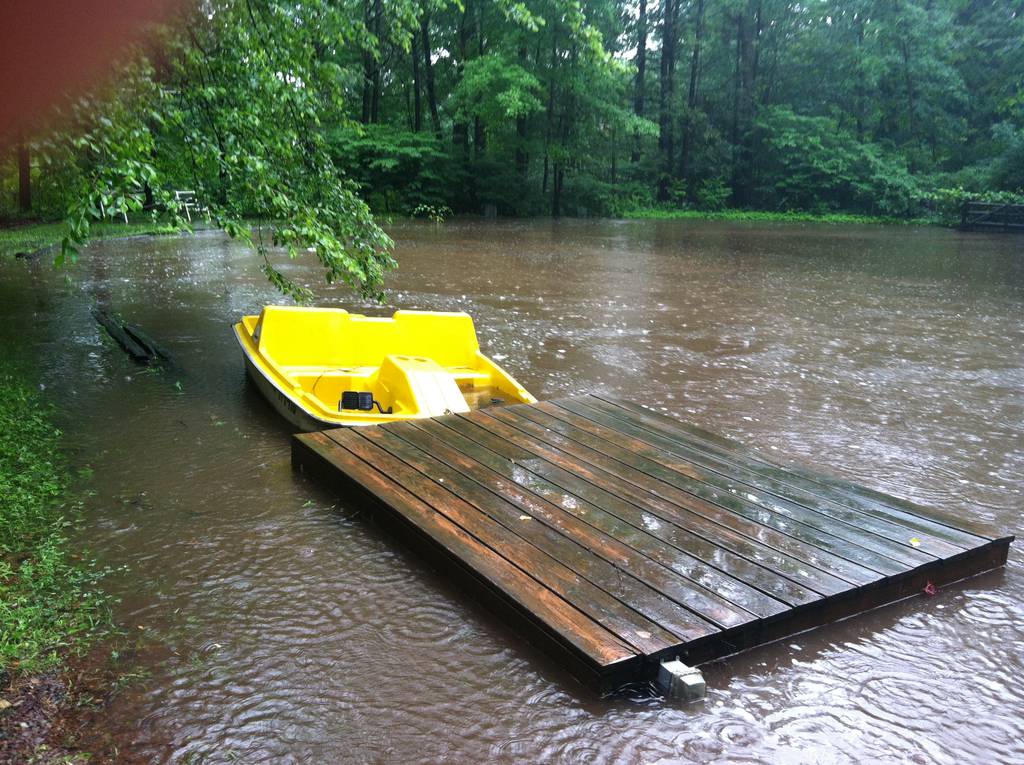
 Another good soaking last night for everyone in our area, right around an inch. Much less as you head east as the storms were weakening as they approached the coast. At work in West Caldwell (Essex County) last night we were hit with a quick shot of heavy rain around 10 -10:30PM. Not even close to the inch of rain we received here in Warren County.
 Lena
Lena Got pounded here in Oxford earlier this morning around 10:30 with some training T-Storms for well over an hour. Judging by the weather station down the road at the Pequest Fish Hatchery it looks like we picked up a much needed 1.92 inches of rain so far for the day.
http://climate.rutgers.edu/njwxnet/dataviewer-stnpt.php?qcarr=&qcreason=&yr=2013&mo=5&dy=8&qc=&element_id%5B%5D=1&element_id%5B%5D=55&element_id%5B%5D=14&element_id%5B%5D=18&element_id%5B%5D=17&element_id%5B%5D=24&element_id%5B%5D=15&element_id%5B%5D=19&element_id%5B%5D=20&element_id%5B%5D=25&stn=1029&states=NJ&newdc=1
Tonight's thunderstorms have pushed us over the top at Pequest.......2.11 of precip in the bucket for the 24 hour period ending in just a few minutes from now at midnight. A good soaker, some of the higher amounts I heard about today were 3 inches in Central Park and around 3.50 in some parts of Brooklyn.
Driving home last night, about 9pm, the sky was lighting up like crazy. From all sides. It was cool to see.
Central Park had over 3 inches of rain yesterday, more than the last 8 weeks combined! The showers were heavier than expected yesterday. Today should be about the same.
Very few tornadoes so far...
http://www.usatoday.com/story/weather/2013/05/09/quiet-tornado-season/2148075/
We could have a few storms around tonight and tomorrow.
3 inches of rain since Wednesday for me.
Could have some frost the next 2 nights, especially Monday night.
As per NWS, snow was spotted today in Tobyhanna PA and at High Point in Sussex County:
"US National Weather Service Philadelphia/Mount Holly
One of our Skywarn Spotters reported seeing snow in Tobyhanna, Pennsylvania (there was also snow seen in Sussex County, New Jersey)."
Channel 7's Lee Goldberg during the 6PM weather broadcast also mentioned snow flake sightings up in Ulster County NY during the day.
Central Park, New York City, Tuesday morning will be making a run at breaking a record low that dates back well over a 100 years to 1878 ( 40 degrees). They're not expected to break it as they're progged to make it down to 42 but you never know. Anytime you start mentioning getting even close to these over 100 year old 1800 era record lows is really something!!
Yeah I saw that report of snow flurries at HP tonight. Crazy. Record lows for our area are around 30 tonight depending on exact location. I'm sure places will be in the 20s but those probably aren't the places that count in the official record books (like Pequest, Walpack, etc).
My basil has been growing nicely. I really hope they don't bite it. I've been looking forward to fresh pesto and caprese salad.
 emaxxman
 Bryan I was speaking with the guys at NWS Mt Holly earlier tonight curious to know if they had an official record low for Tuesday morning for Pequest. Unfortunately they have no records as Pequest isn't a climate or co-op site.
Wow here it is only 9PM and High Point (36 degrees) and Walpack (38 degrees) are already down to the 30's. There looks to be problems with the Pequest station as the temperature hasn't been updating on the website the last few days:
http://climate.rutgers.edu/njwxnet/station.php?s=1029
I'm a couple of miles away from Walpack Vic. It is cold up here. I just checked and I'm at 37 now. Curious to see what tomorrow am brings.
 M & K
M & K Down to 37F now here on the west side of Htown. It was 35F here this morning so if the wind remains calm would expect a morning low near 30F.
27 in Walpack 29 in Sussex. Not t-storm weather! But it will warm up esp by tomorrow.
Thermometer outside my kitchen window read 30 when I got up at 6. And I found the frost blanket wedged in my trunk. Maybe I'll keep it. Plants survived last night. I put a few flats in my trunk and they did well.
Whew.... only 5 States away from us it got up to 106 degrees today. The heat was on in Sioux City Iowa:
http://kamala.cod.edu/ia/latest.nous43.KDMX.html
Personally, I'd just as soon have the weather we did the last few days than what they had in the Midwest today. Plenty of time for scorching heat all summer. I'm in no rush to get there.
Any chance of seeing some rain in our area tonight or tomorrow? The radar on the news tonight didn't look too promising. I don't feel like watering the plants. ;o)
Each day brings a little better chance but overall Thursday gives us the best chance. That's when the same front that affected OK will move through here with a severe t-storm threat.
It was a very active weather day a couple hours to our north. Tornado confirmed today in Copake, NY (Upstate NY):
http://www.turnto10.com/story/22378251/tornado-confirmed-in-copke-ny-on-mass-border
Bryan does it look like the weather will be bad on Thursday around 5p.m.? My daugher is traveling by bus to the State Theatre for the Freddys at that time. And then home after 9 or later...Thank you!
The timing of most of the storms would be tomorrow afternoon into the evening so yes i would think if someone is going from H-town to New Brunswick at that time they are bound to hit something. It sounds like they are leaning towards strong storms (as opposed to severe) at this point at least.
Keep a eye out today for severe storms - http://www.wunderground.com/radar/radblast.asp?num=6&delay=15&scale=1.00&noclutter=0&ID=DIX&type=N0R&lat=40.96670151&lon=-74.76670074&label=Andover%2C+NJ&showstorms=10&showlabels=1&rainsnow=0
storms all around today: quess we should keep an eye to the sky. any major concerns for later on today?????
We are in the 'slight risk' category for severe storms today. So we'll see. They will be spotty at first but more organized later and this evening.
http://www.spc.noaa.gov/products/outlook/day1otlk.html
Bryan,
Is there a good place to a multi-day forecast at a glance that includes a humidity forecast?
Washington had a delightful, very heavy down pour this morning with a few rolls of thunder. Hoping Hackettstown and all areas around who needed the rain also got this soaking...
Poured just as the dog and I were parking for a walk. Decided to come back to the house and just walk on our road. Within 20 minutes, just as I was going to turn around, it started up again. Ugh- wet dog smell.....
MG - i never really looked for that. Try weather.com or accuweather.com. They seem to have details that you can break down.
Actually try this MG
http://forecast.weather.gov/MapClick.php?lat=40.85380&lon=-74.8254&unit=0&lg=english&FcstType=graphical
That's the direct link but to get there just go to noaa.gov and type in your zip code. Then under 'Additional Forecasts And Information' click on 'Hourly Weather Graph'
Bryan,
Thanks. Closest one I have found.
Seems funny that you gots your highs, lows, wind, and general overview (sunny, not so sunny, etc.) and maybe even a heat index (which you can guess relative humidity from) but yeah, humidity not a forecast item even though it really determines overall environmental comfort in at least 3 seasons a year.
MG - i think part of the reason is the Dew Point is what you really need. Humidity is relative. You can have 90% humidity at 32 degrees with a dew pt of 30. That air does not feel very humid. But 80% humidity at 92 degrees with a dew pt of 70 feels horrible. Humidity is always relative to the dew point vs the temp.
 LM
LM So as far as the next 10 days or so here's the way it's shaping up:
*We start out the holiday weekend cool and showery with a good amount of wind. Overall it will improve as we go along. Sunday is ok and Monday is a decent day.
*Next week we warm back up to normal then eventually it's looks like a heat wave will affect us in some way late week/next weekend.
 maja
maja A storm is possible late in the day today (Tues). Could be strong.
How about that 30 inches of snow in the Adirondacks Memorial Day weekend?
http://news.yahoo.com/3-feet-snow-upstate-ny-memorial-weekend-025106821.html
 Coralie
 weather channel has north nj on the torcon tornado scale today. think it said 2-3 as it scrolled across bottom of screen. today looks difficult across a very wide area of the country. holding my breath for everyone in the path of what might be a damaging weather day.
Bryan, how wide spread is it going to be? Will it affect the DMB show in Scranton potentially?
The storms will be coming down from NE PA so i think it could as least affect the tailgating ian. There will be probably be 1 or 2 lines around but overall whatever anyone gets shouldn't last too long.
The latest discussion from the Storm Prediction Center in Norman OK concerning the scattered strong to severe storm potential later today:
http://www.spc.noaa.gov/products/md/md0853.html
my weather.com site for hackettstown already says potential strong storms for Sunday. any comments? Is this front the same one causing tornado activity in Oklahoma today and tomorrow?
 copygirl
 20% chance of a storm Saturday, 40% Sunday. Mainly PM. By Sun night those chances go up into Monday. Typical summer weekend albeit a little early.
Discovery Channel storm chaser Tim Samaras died along with his son, Paul and coworker, Carl Young in El Reno, Oklahoma during the storms Friday night - http://philadelphiaweather.blogspot.com/2013/06/storm-chasers-part-of-oklahoma-fatality.html
Bryan, what's your thoughts on today...headed to a birthday party in Bayonne (outside, of course), and according to the NY stations, storms expected up here after 12 and closer to the city between 3 and 5. Your thoughts or any other weather predictors thoughts appreciated.
 Bessie
 The forecasts that I have seen say there is a possibility for strong to severe storms to develop, which could lead to damaging wind gusts over 50 mph, large hail, heavy downpours, and frequent lightning. Even a weak isolated tornado cannot be ruled out. Channel 2 said the storm should hit NYC around 5 P.M. I don't think they'll be able to play the Yankee game tonight. Once we head into the overnight hours, the severe threat will diminish and heavy showers will be the main concern. Be safe.
That seems a bit early to me Bessie. Especially for Bayonne since they will be coming from the west. Radar looks quiet now. But at some point late PM and evening there will be storms around and they can definitely be severe.
BLD - some of TWC crew are lucky to be alive after what happened to them. I didn't realize that some of the chasers were actually killed though.
Bessie - I figured, but the joke is kind of lost if you didn't read the thread about the parade and the library float losing their shark balloon. ;-)

Think Mike Bettes needs some new boxers...... Wanna bet he goes for the desk job..
Wonder how they will make a 30-minute show out of a 60-second tumble?
Hope you never experience something like this MisterG. You are aware that people died in these storms - http://www.wptv.com/dpp/news/local_news/mike-bettes-weather-channel-meteorologist-sustains-minor-injuries-after-vehicle-thrown-200-yards
Way too early of course but there could be some type of tropical system/noreaster affecting us this w/e. Of course we are not talking about a Sandy here but heavy rain could be a possibility. Hope not.
wow really Bryan, thanks for the weekend update, much appreciated. tropical system this early in the season....
Hi Bryan, I would love updates on Saturday's weather. We have an outside kids party planned from 1 - 3pm. If storms are definite for Saturday then I will use my rain date. Thanks.
 Lilly
Lilly Regardless of the semantics it looks pretty wet around here Thurs night/Fri/into early Saturday at least. We can at least be hopeful it improves Sat PM but it's way too early to say for sure.
They didn't expect Sandy to turn out the way it did, so anything is possible. Once they say "noreaster" its time to take precautions.

BLD: I have experienced this a number of times living on the Great Lakes and trust me, I would never go looking for it. My last one included an 80 foot tree coming passing by me within 8 feet and it will take a few more years for me to rest easy during a major cell. It takes time.
I was serious when I said Mike would probably be going for the desk job. His interview has that familiar tone of the ptsd shell-shocked which I know very well. And yes, his adventure was all about the 30-minute show, not much about the science there.
But these boys, may they rest in peace, died in pursuit of science: http://abcnews.go.com/US/remembering-tim-samaras-veteran-storm-chaser-killed-okla/story?id=19309689#.Ua3YNRXD8y4 They were good, they were experienced, they were outfitted with the best spotting technology and tragedy still hit. It is a very serious game and there are way too many adrenaline junkies playing today for fun and profit.
Along with the serious scientists, there are tornado tourists, thrill-seekers (of which you need to include Mike and co.), and all sorts of bumpkins chasing these things. Here, you can play too from your basement: http://dsc.discovery.com/tv-shows/storm-chasers/games-and-more/storm-tracker.htm
Here's a picture a just a few chasing; note how many are seriously out of place. So, yes, I have been there, and yes, I actually hope Mike does go for the desk job and talks a few wanna-bees out of trying to catch lightning in a bottle. But I don't think a weather channel 30-minute special on his experience will do that. Quite the opposite.
It seems there is a difference between the professional storm chasers who do it to report on the location of the tornado and those who try to get close to collect scientific data. I think they got too close in the name of science. Prayers to their families who are left to try and make sense of a terrible loss.
Totally agree with you MG. Mike already mentioned that this may 'retire' him from storm chasing. And it's a shame that all these wannabe storm chasers were clogging up the roads and getting in the way of the ones who know what they are doing and are actually doing important research. But that's another story.
BBU - Sandy was everything it was expected to me. Unless of course you were listening to Bloomberg who had his head up his ass.
At first they didn't forecast it as anything to worry about. Just another noreaster. Only a couple of days before it hit, they said it would be something to watch. So, Friday could turn out to be anything. Just be cautious.
"Unless of course you were listening to Bloomberg who had his head up his ass."
...as per usual, on everything. lol
 JeffersonRepub
 A storm like Sandy couldn't really happen this early in the season. The set up wouldn't be there. But yes Tracy the water in the Atlantic is too cold. The moisture coming up Fri/Sat will be coming from the Gulf and it will probably fuel a cold front which may also spawn a coastal storm. Lots of ingredients that's why it's tricky.
Never say never. My not be a tropical storm, but any kind of storm can have a damaging affect.
That's true. Damaging weather can happen any time during the year.
No real change to any thinking. Not quite sure where the real heavy pockets of rain will set up but either way it will be pretty rainy. Still hopeful for some drying by Sat PM. The general trend of cooler weather, with the occasional blip, will continue.
 JD 4020
 Some of the forecasts say Saturday will be rain all day and one (accuweather) says it will be done by 2pm. My outdoor party starts at 1pm. I don't want to use my rain date yet, but I do want to give people notice. What is your opinion Bryan?
The reason you see 2 forecasts is because the models haven't come into a consensus yet. My gut feeling is that we will be drying out Sat afternoon (assuming you are in Warren cty). It may still be wet and mostly cloudy though.
Lilly - When is your rain date? If it's Sunday then go with the rain date because Sunday is the pick of the weekend and should be pretty nice.
Don't be so sure about Sunday. A very unsettled pattern is coming up. It should be much better than Saturday but it may not be completely dry.
tropical storm has formed wow Tropical Storm Andrea, the first tropical cyclone of the 2013 Atlantic hurricane season, has formed in the Gulf of Mexico.
The NWS has put up a brief for the storm. Looks like a good 3 inches of rain are possible. I guess I'll go hoard some gasoline before the lines.
http://www.erh.noaa.gov/phi/briefing/packages/current_briefing.pdf
Unbelievable track. I have a feeling people may overreact a bit to this after Sandy. Some flooding will probably be the main threat. I think LI would see the strongest winds.
http://www.nhc.noaa.gov/graphics_at1.shtml?5-daynl?large#contents
As of now Sunday looks decent. It's all about timing. Areas of showers will be rotating through the area even after Andrea passes by.
"Tropical" storm Andrea heading our way. Will be less powerful when it gets here Friday, but still a "Tropical" storm. Coming from the Gulf of Mexico, where the water is warm.
Hi, our party is right at the border of Warren Cty and Sussex Cty at Tranquillity Farms. And our rain date is for next Saturday the 15th. I wish I had put Sunday down as the rain date. If I postpone the party it would just be my luck that it will rain next Saturday. I think we will take our chances and keep it for this Sat. We can run in the green house if it starts to pour ;-)
At weatherchannel.com they are showing rain next weekend, but its WAY too early to forecast that. They can't get day to day right, never mind a week from now.
Wish you the best with your party Lilly.
Any ideas on power loss in h town with this storm? and the river flooding since it is high and the ground is already pretty saturated?
 Concernedlady
 Just came from Mountain Ave. and the road is flooding in the area of BK, Lowes, Mama's
Be careful!
yeah i live right off that road....and its only gonna get way worse when the real heavy rain come
I hope is ok today.....I have to go to Hackettstown hospital with my son for testing at 400....
Lilly - When is your rain date? If it's Sunday then go with the rain date because Sunday is the pick of the weekend and should be pretty nice.
BLD
3 days ago
Don't be so sure about Sunday. A very unsettled pattern is coming up. It should be much better than Saturday but it may not be completely dry.
Bryan
Weather forecasting is an inexact science....Bryan has always been reliable and up front about the fact that nothing is written in stone.
And here comes the rain again (isn't that a song lol). BTW i was posting on the Andrea thread and i did mention that this past weekend was looking better, esp Sunday.
So after posting that my forecast was wrong, you had a moment of clarity and realized it was more accurate than your initial forecast...and it was!
I hope Lilly had a great party.
**yeah the weekend is looking better and better. Can't rule out a shower or two tomorrow but overall not as bad as we thought a day or two ago.**
Bryan, luckily, on Friday, I saw your updated weather on the Andrea thread, and didn't alter any plans for the weekend. Got a little dark by Citi Field at Saturday's game (in more ways than one), but no rain. Thanks for the time you and the other weather people put into this forum, always appreciated.
No prob Bessie. Glad you caught it. I hope you didn't stay for all 20 innings of misery lol.
Actually, it was Clyde, his brother and niece. They had a good time but left early so they didn't sit through the misery, LOL. I was soooo happy I wasn't there.
Oh btw most of the models show a pretty significant rainmaker for Thursday/Thurs night. We really aren't supposed to get organized rainstorms in the middle of June. This is nuts.
Yeah Bryan I saw that too. Possible 2+ inch rainfall again. Crazy. I noticed earlier today that the Pequest River is just about maxed out.
Well hopefully this means no brown lawns next month! lol
The biggest threat to our area Thursday is heavy rain. There could be a t-storm. However just to our south (south jersey, Delmarva, etc) could be in for some very dangerous severe weather.
Totally nuts!!!! The weather just keeps getting stranger and stranger. Today is the calm before the storm.
They are talking about "derecho". If I remember correctly, didn't they talk about that before Sandy hit?
No a derecho is something different. A derecho is basically like a severe t-storm that can cover 100s of miles. We will be on the edge of that it looks like. It should mainly go south but we should keep an eye on it and either way it will be windy and rainy.
I just got the JCP&L courtesy call reminding me that I am a well water customer and should take precautions due to the storms that are coming through tomorrow. Gee thanks, I really forgot I have a well. LMAO
Beat me to it Calico....I was just going to post that. I was on the phone with my husband who just got hit from behind driving home. Great....
So very grateful for your weather postings here Bryan...A person can get dizzy watching the weather predictions on the tv channels which are always different...Thank you!
 Christine
  3wbdwnj
 3wbdwnj - From the forecasts I have seen the primary threats of this storm will be flash flooding and wind gusts over 60 mph in heavy downpours. We are to the north of the warm front which will mean winds will be from the east and southeast at 10 to 20 mph. The heaviest rainfall and embedded thunderstorms will move through the region from 3 PM through 10 PM. Rainfall amounts will range from 1" to 4". There will be lingering showers through Friday with winds back to the northwest at 15 to 25 mph.
Looking ahead past the next few days better overall weather (i.e. real summer weather) seems to be on the horizon. Especially mid-week on...
Looks like the majority of us escaped any severe weather effects on Monday. I've heard of some damage reports coming from down in Clinton and in Readington Twp. This report via Facebook from someone in Readington yesterday:
"Stanton section of Readington Township, Hunterdon County. At 3 pm received 0.52 inches of rain in 10 minutes. Ground was covered with3/8 inch hail. High winds blew down trees and branches. Springtown Road is blocked by a 10 inch diameter tree branch."
An increased chance of storms for later on today so keep an eye to the sky.
Yeah there were no storms north if I-80 yesterday in our area. The few there were packed a punch though. Today's storms will be more widespread. Not expecting severe. Biggest threat very heavy downpours later today into this evening.
After that like i said we evolve into more of a summer pattern. You could say we are already there.
No "storm" but definitely "downpours" yesterday. Its getting a little too soggy around here.
WTH?! Nothing but rumbling for 2 hours and barely any rain. Now the sun is out. My lawn wants some rain.
Doesn't look like it's all done on the north part of the town.
And I can say for sure that I've got a cat that takes issue with the phrase "nothing but rumbling" as if that wasn't the worst, most scariest, horrific, awful, go run and hide sound in the world.
Looks like we are in for another round this afternoon. Round and round she goes.....who gets hit....nobody knows. :)
We got a bit of it already 10 mins ago, just a bit of a sprinkling for a few mins. There's a really nice wave right around Bangor at the moment. Looks like it might go north of Htown proper, but Allamuchy or Green could get a real quick jolt.
Some thunder-boomers in PM but no rain yet
Now its 1/2 hr later and its down-pouring!!!
Independence getting some thunder and a bit of rain now...Hubby had a "rude awakening" while taking a snooze in the backyard hammock a few minutes ago...
 joyful
 OMG Joyful. The thunder coming thru probably sent him 10 feet out of the hammock. :)
Yes, indeed it did plus by the time he got in the house he was a bit wet!!! @botheredbyu
This is a strange storm......it starts raining and then stops...the sun comes out and then it starts all over again.
keeping the thread active as the storm threats start coming in for today and tomorrow.
Any comments from Bryan on the "severe storm threat " for Thursday? Should we think about pulling everything in?
 Dansker
 I've been in Calif. Back now, catching up. Very little rain while I was gone. Sounds like showers and storms over the next 4 or 5 days. Overall Thursday being the worst and there is a flood watch out. We are in the 'slight risk' category for severe on Thursday.
 abbadabbadoooo
 At least from the radar it looks a lot different than yesterday. The previous storm was very isolated and hit and miss. Right now the radar shows a solid line from the northern most part of central PA right down to the southern part of Maryland. The previous storm was "weird" off & on. This one should be solid.
But then again, I'm no Bryan. ;-)
It looks scary. Batten down everyone. Close the umbrellas and get those toys in the house.
BBU - Check this site out, (I posted it earlier)
http://www.wunderground.com/radar/radblast.asp?num=6&delay=15&scale=1.00&noclutter=0&ID=DIX&type=N0R&lat=40.96670151&lon=-74.76670074&label=Andover%2C+NJ&showstorms=10&showlabels=1&rainsnow=0
Thanks BLD! Looks like its heading north of us. Lets hope.
Oh, just saw News12 and its showing coming west to east. Oh boy!
I don't know how the radar can miss such a wide spread storm. Two national news weather just specifically mentioned Mansfield Tsp and Port Murray as right in the path. Can't be that good.
The news on channel 2 just said that the 2 storms will collide and cause havoc. We are hearing thunder now.
And it's now pouring right at the time they said it would. NYC Channels are right on the money.
Got stuck in the downpour walking home from Quick Chek...Thank you to the young man who shared his umbrella with me to my corner..Got soaked but it did feel good! I could have done without the thunder & lightning..
got my Morris County Office of Emergency Management phone call and email reporting Tornado Watch until 10pm. Very Quiet here now.
It was crazy over in Port Murray...dont take Penwell the road is all washed out and gravel all over and water almost to my door
 Nosila
 GC - that's exactly where it hit. I had three trees down within 5 minutes from rain n wind. Hackettstown looked like they had nothing. Lucky us here in mansfield/long valley
 Nik
Nik Left Atlantic City about 6:30 last night on a bus heading for Hackettstown after spending a day of great weather for getting out on the Boardwalk and enjoying the day. About half way home the skies opened up and we heard that there was indeed a tornado watch going on for the area. Needless to say, the bus driver received a standing ovation for his efforts in getting us all back home safe and sound.
joyful - Hope you had a great time. You missed some really crazy weather. PM got hit hard and went thru Beattystown about 7pm and there were branches and leaves down everywhere. Scared the hell out of the cat and dog. I think more today.
This is the worst summer weather pattern I can ever imagine. It is going to last probably into late next week at least. It looked like things were improving but now we are back to the endless rain.
@botheredbyu: Our bus trip left yesterday morning early from Port Murray School and it was just about 7:30 or so that we also mid way home and got hit hard as well. By the time we arrived back at the school the rain had stopped for a bit but when we arrived back home in Hackettstown...as you know... it started up again. I could tell by the roads in Hackettstown and side roads that it must have been bad as there was some flooding on back roads on the way home.
We are waiting for a few straight days of no rain to get our driveway sealed. Oy vey....another week wait, though I do feel bad for those businesses that are dependent on good weather.
Hoping for a decent day on the 4th also. Plus all this rain is making the bug population explode around here.
My rain gauge measured 4 inches from yesterday- can that be right? The rain was so loud- not the thunder- that we couldn't hear ourselves speak last night.
Know anyone in the Scranton/Wilkes Barre area of PA? They were in the "comma head" of yesterday's storm system and got absolutely pummeled last night with hours and hours of torrential rains stalled over that area.
http://wnep.com/2013/06/28/flash-flooding-causes-evacuations-flood-gates-closed/
http://thetimes-tribune.com/news/officials-say-flooding-is-imminent-early-friday-morning-1.1512329
For those interested, storm totals from that areas NWS Office:
http://forecast.weather.gov/product.php?site=BGM&issuedby=BGM&product=PNS&format=txt&version=1&glossary=0
Locally, had right around 1.50 inches at Pequest from yesterday's storm. Looks like Hackettstown did a bit better with a tick above 2.00 inches. I wouldn't be surprised if there were some extremely localized areas around the Hackettstown area that got more.
Just saw this. Looks like a general 2 to 3 inches from Mercer County on north according to the folks at NWS Mt Holly:
http://forecast.weather.gov/product.php?site=NWS&issuedby=PHI&product=PNS&format=CI&version=1&glossary=0
Rader looking active in PA now and looks to be headed this way if they hold together.
720am and raining in PM. I think its time we build an ark. At least we'll save on gas. :)
Flash flood warnin in effect.. Major flooding in Northampton county, many roads under water and homes with water running through it causing structural damaged.
 Justspeakinthetruth
 It was pouring rain when I left Hackettstown at 7:45am and its still pouring hard rain down at 9:32am in East Hanover. ugh.
 mom of one
 It looks to me like the rain in PA was moving very slowly. In NJ now it seems to be moving through pretty fast so any flooding issues here would probably be more localized. But this is going to be the general them the next few days. Lots of moisture in the air. When it does rain it could come down in buckets. Be on the lookout for flash flooding.
coming down in buckets up here on Schooley's Mt right now
I am so sick of this weather.
 4paws
4paws  Mariann
 So we need to get through tomorrow and the prolonged rain should be over. A heat wave type pattern is starting to show up on the models especially after Wednesday. Of course you can get t-storms in that type of pattern but not necessarily every day or anything prolonged as far as rain goes. The rest of this month is looking pretty hot, at least according to the pattern setting up on the models. Finally.
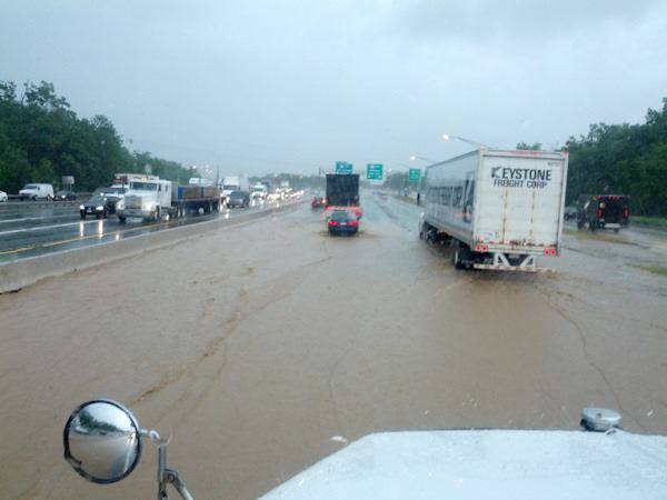
Another crazy weather day. NWS has now confirmed an EF-0 touched down this morning in Berkeley Heights NJ that was on the ground for 4.8 miles. The attached pic shows RT 80 this morning in Parsippany. So glad it was my off day!
Yeah Bryan the construction is nuts in that area! I can't even tell you what exactly they're doing. I think it has to do with drainage improvements but they are also playing with those sound barrier walls so I don't know. I'm sure all that brown water in the pic came courtesy of the runoff from the many steep grassless dirt slopes within that few miles of construction area.
I thought the original plan was to add a lane for the 287 exit but who knows. They are also doing a lot of constructions on 15 which also screws me up and that's another project that no one is quite sure what the heck they are doing lol.
Just got a Severe Thunderstorm watch until 10:00 tonight, what do you weather watchers think? Will it cool things off a bit or fizzle out?
We need it bad. Too many days of temps over 55 degrees. (yes, not a typo, 55 degrees is right about ideal I don't care who you are ;-)
The radar west of Scranton is lit up like a Christmas Tree, I say booyah!!
We need it to cool down about 10 degs. No more than that!
It does look like a line of storms is coming through. NOAA says between 8 and 9 or so. Not everyone will get a storm but everyone should at least see a decent shower.
-Bryan
 Lisa21
 Actually the northern part of that line looks pretty broken. Towards south jersey it looks like it will be stronger.
Not a drop of rain yet and Directv is flaky already!
Sounds like GC is part Eskimo.
Port Murray just got hammered....of course right when I got done watering everything
Hail reports coming in from Flanders/Roxbury area.
Got some cooling breezes before here in Oxford but not much in the way of rain. Looks like it just slid past us per radar.
 Rebecka
  EG_1982
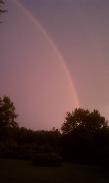
 Wild Angel
 Vic - What part of Oxford are you in? We are in the Jonestown area and got a ton of rain. It was coming down sideways!
Just missed me to the north and south. Got a little rain but mostly wind and lightning bolts.
Hi Calico,
I've seen on occasion when I report heavy rain you don't get much on your side of town or sometimes it can be the other way around like today! Pretty amazing since the town isn't all that big. I'm just off Pequest Rd in the northeastern most part of town in the development not too far away from the Pequest River and down the road from the Pequest Fish Hatchery. I like checking in on the Hatchery's weather station since most of the time their weather is my weather :-)
Funny that you mentioned that, Emaxx. We got a ton of thunder and lightening and a quick pour, and it was the first time in months that the DirecTV didn't even flicker. When we first got the satellite we didn't have any issues, but more recently, it was going out before it would even rain. Today, not a bit. My husband called them the other day to switch our premium channels and he mentioned it and they said they had been having some issues of late. Anyway, sorry for the hijack.
Tropical Storm Chantal has formed in the Carribbean. Expected to turn towards FL by the weekend.
My 29 year old son called from his home in Rockaway last night asked " Did you get that storm tonight?" Well we had some typical thunder rain lightning I said. He said that was the worst storm I have even been through even worse than the two hurricane type storms I went through at Univ of Florida. They lost power. First time I have heard him somewhat frightened. they went out and got a generator.
it got really ugly in minutes in Washington (Warren) , hail and a lot of rain.
 BrownEyesGuy
 The storm put a "damper" on the concert at Shippen Manor last night. I hope the musicians were able to keep their instruments dry. Up until then, it was a fun night.
At least the storm held off till well into the second set.
 Ms Fishy
 Re: yesterday's deluge... Although the storm didn't last terribly long, I think it may have been the hardest I have ever seen rain come down, or at least tied for first place...
It was the first time that I had some issues with my Direct TV in a storm. We have barely lost Direct TV during the heavy snow storms and we did not lose it at all through hurricane Sandy so it must have just been how the clouds and lightening rolled in.
Got a quick very heavy storm then everything was back to normal.
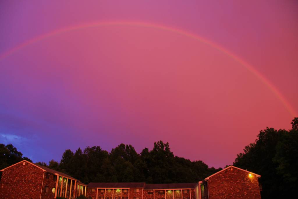
Thanks for the pic of the double pink rainbow, nice end to a nasty heat wave!
It was weird seeing lightning flashes behind that rainbow as another storm was passing southeast of us.
Cool air feels awesome.
 redmink1
 Cool air isn't even close. A nice drop of another 20 degrees and we can at least begin to talk. Yuck.
emaxxman - I would prefer Sami to Innuit. Less fish, more reindeer. Others are ready to retire south, I want to retire north. Hit $6 mill in the lottery and no Florida for me, I'm off to Shawinigan or Timmins.
just coach - Morris County got pelted just like your son said - hope things are better today - http://www.nj.com/morris/index.ssf/2013/07/photos_storm_was_worse_than_sandy_thousands_still_without_power.html#incart_river_default
 Chickadee
 Sunday night's storm ripped the roof off the Dover Library - http://www.dailyrecord.com/article/20130708/NJNEWS/307080032/Storm-rips-roof-off-Dover-Library
T-storm coverage should increase as we go through today into tonight and possibly even the first part of tomorrow as a cold front approaches. The only thing the front will do is keep us out of the 90s for a while.
The good news is that from the forecasts I have seen a Canadian high pressure system will take hold Friday on through Sunday bringing very pleasant weather conditions. Expect scattered cloud cover but no threat for rain. Humidity will be very low and temperatures will be near normal. Enjoy the refreshing weather because it won't last, unfortunately.
A new Bermuda high pressure system will bring the return of hazy, hot, and humid weather conditions on Monday. Showers and thunderstorms will be a returning threat with potentially the remnants of tropical storm Chantal coming northward.
Bryan - Why is it that every time it rains, it's a severe thunderstorm? Is it just my erroneous perception and this is normal for summer rain? Or are we, year over year, seeing more frequent and severe thunderstorm systems?
Just curious.
I don't really see it that way emaxx. Maybe there have been more severe t-storm watches. I can believe that. But most of them haven't panned out. That one on Sunday was pretty isolated. If you take the tri-state area as a whole i do think there has been an increase in tornadoes over the last 8-10 years or so though.
I dunno; we seem to get more "super" storms, more nor easters, and more "that's not right" weather lately. And pummeled during the last two years from Maine to Maryland and beyond, last four or more years coast to coast.
Remember when El Nino represented a huge weather shift?
Personally if folks don't see we are the tipping point or beyond for global climate change, I think they're smoking something (and not sharing). Once we shift those deep sea Ocean currents it's all over for decades, century's, who knows ----- forever. And then all of JRs and BDogs guns aint' gonna help them from the resulting chaos, the result of which will be the roaches ruling the world in our place.
We are stewards of our world and we need, as a world, to clean up our act. It's a world-wide effort but only the US has the leverage to tell China, etc. what we will accept (buy) or not. And it's not free, it was cost us today to save this world for our children tomorrow. Right now we are not putting money in the bank, we are withdrawing big time.
from NRPS
HEY LOOK IN THE AIR
THERE’S SMOKE FILLIN’ EVERYWHERE
AND HEY, LOOK ON THE GROUND
THERE’S BLOOD SPILLING ALL AROUND
CHORUS:
WE LIVE IN THE GARDEN OF EDEN, YEAH
DON’T KNOW WHY WE WANT TO TEAR
THE WHOLE THING TO THE GROUND
WE LIVE IN THE GARDEN OF EDEN, YEAH
DON’T KNOW WHY WE WANT TO TEAR
THE WHOLE THING DOWN
HEY LOOK AT THE GREEN, GREEN TREE
IT AIN’T QUITE AS GREEN GREEN AS IT USED TO BE
AND HEY, LOOK AT THE COOL CLEAR WATER
IT AIN’T QUITE AS COOL AND CLEAR
AS IT OUGHT TO BE, AND
CHORUS:
WE LIVE IN THE GARDEN OF EDEN, YEAH
DON’T KNOW WHY WE WANT TO TEAR
THE WHOLE THING TO THE GROUND
WE LIVE IN THE GARDEN OF EDEN, YEAH
DON’T KNOW WHY WE WANT TO TEAR
THE WHOLE THING DOWN
HEY LOOK AT THE PEOPLE
SOMETIMES WE FORGET
THAT WE’RE JUST PEOPLE
AND WE’RE FALLING HEAD OVER HEELS
‘CAUSE ALL OF US FORGET QUITE HOW TO FEEL
WE LIVE IN THE GARDEN OF EDEN, YEAH
DON’T KNOW WHY WE WANT TO TEAR
THE WHOLE THING TO THE GROUND
WE LIVE IN THE GARDEN OF EDEN, YEAH
DON’T KNOW WHY WE WANT TO TEAR
THE WHOLE THING DOWN
Well I would say we've been lucky the past year, almost two, but some have only missed by a mile. In general, from my 30 years, yes, they are worse, bigger, and more sustained.
And yes, the weather channel especially has been a disaster forecasting them amongst other misses. My favorite is take any heat wave forecast and add a minimum of two extra days. I think their ineptness is due partially to a bad computer (which I heard we got budget to fix), partially due to ratings, and partially due to our changing weather environment. Seems like we are in a new weather era.
Looking pretty quiet today. Storm chances have gone way down. Overall the bark has been bigger than the bite lately. Can't complain.
I mentioned about 2 weeks ago that this month is looking pretty hot. After this little blip right now we are really going to bake. Especially next week. And it looks like it will be here to stay for the most part (thinking a pretty good stretch of 90-100 deg temps with any t-storms few and far between).
What does "here for the most part" mean..through July, the rest of the summer? Please say it ain't so!
Great, ac was running constant last week with the heat. Do not want to see the electric bill from to long a stretch of 90 to 100 temps.
 jdem
jdem Basically a prolonged stretch of hot weather with no more than a day or so break over the next 10 days. Upper 80s to around 90 Monday and it will get worse from there. I don't like to predict patterns beyond that range but the general pattern for July seems pretty locked in at this point. The heat will win the battle overall until further notice.
Sounds like that persistent Bermuda High will be anchored out in the Atlantic until further notice. Time to get the central air cranking!
http://www.nj.com/weather-guy/index.ssf/2013/07/scorching_week_expected_in_nj.html#incart_river_default
Ugggh! My bill is going to be soooo high. It was $164 last month and we didn't use the a/c too much. It's been running fairly constantly lately and looks like no end in sight. :(
I hear ya Calico! Sometimes I wish I did not have central air. The only room we really need it is in the bedroom. My other rooms are hardly used. I definitely cannot live without it though. My bill between the pool and a/c was over $300. The store was over $400.
Got the electric bill down to $74 bucks in May. The latest bill that just arrived days ago jumped to $125 I'm guessing from running a new portable air conditioner we purchased. I cringe at seeing the bill whenever the central air unit is used!
we have central air.....put an air conditioner in the bedroom window for sleeping. I dont mind the heat when I know my money is staying in the bank. :-)
Ceiling fans folks! During last year's heat wave, we kept our AC at 76f and all rooms had fans on. We actually felt cold. A fan does wonders. Our bill was no more than $200...normal without AC was about $95.
I have ceiling fans in every room. Cannot live without my fans! BUT our a/c is on 72. I do not do well in the heat at all.
My generation didn't have a/c so we got used to the heat even upstairs. Since I'm older now, I have box fans in kitchen and bedroom. In the past 40 years, it's all I have ever needed. (guess I'm lucky) Electric bill is about $50 a month. Looking forward to the "heat wave". Did I say I love summer? Love winter too?
My AC is at 74 because I melt. ;-)
But this is where switching electric suppliers has paid off for me. Normally my electric is really low, yet this month was $132. But two years ago before I switched it was $185 for just a bit more kwH.
GC it has helped me also. BUT the store it has hurt me as the energy companies have charged me for delivery. They are not regulated for commercial accounts so they can charge whatever they want.
Any storms during this heat wave will be isolated. Friday might give us a better chance but then on Saturday this heat wave won't go down without a fight. Saturday won't be a washout by any means but i would expect some pretty strong storms especially PM.
Christine - I have family that lives in NC and they are on the budget plan with their electric company. They have CA and a pool and with those and regular electricity use, they pay $220 a month. Don't know if Jersey is higher, but worth checking out, if you haven't already. They have 5 people in the house.
Bryan - do you have anymore info for Saturdays storm? I am really hoping it doesnt hit us. I am still waiting on tree people to cut down two big trees.
Not really Nik sorry. It just looks like it will be later in the day. As far as severe weather it's usually very hit and miss. But with a cold front i would imagine most areas will have some type of nasty weather. We'll just have to see how the radar looks as the day (Saturday) goes on.
Yay! Finally got the driveway sealed! As long as the rain waits until later on Saturday I'm good!
It looks like a majority of the severe weather will go north. We will still get some storms later tomorrow/tmrw night though.
Did any one else in the Great Meadows area just hear thunder ? I fear the storm is coming.
emaxxman- ha ha ha! Don't even joke! You know how people on this forum feel about snow.
 Livinglifelovinglife
 I know how I feel about snow.....
Sleigh bells ring,
Are you listening?
In the lane,
Snow is glistening.
A beautiful sight,
We're happy tonight -
Walking in a winter wonderland.
There were some storms around but never a solid line. Pretty much a dud in my book. I think Central and South Jersey may have done better.
Agreed as far as being a dud for us. I think far Southern NJ was the winner late last night as far as precip in the good ol rain bucket.
Was really hoping to get some much needed rain yesterday but it didn't happen. The lawn has gone brown quick the last few days!
No rain + dried up lawn = saved gas and time. Gotta go now the baseball game just came on. LOL!
We got a cooldown, BUT no rain! Hopefully this storm will reach NJ. It seems that between the Appalachians and the humidity rising out of the Delaware River, only the more robust storms do not split north and south of us.
This week looks pretty active. I don't see any washouts but a 30-50% chance of showers/storms pretty much every day. Nothing overly severe but heavy downpours possible.
 Mike L
 Raining thunder and very dark in Hope rd section of Great Meadows. Need the rain, thank you for some rain.
Yay rain! Of course it started just as I was going outside to take care of something....
Torrential rain near Hope Rd Great Meadows. Satelitte is out. Fingers crossed power stays on.
A TON of moisture currently back in SE PA (Harrisburg/Lancaster) slowly moving Northeast that will need to be watched. If it holds together overnight and make it's way into Warren County it could cause some headaches for the very early morning rush.
http://www.wunderground.com/radar/radblast.asp?num=6&delay=15&scale=1.00&noclutter=0&ID=DIX&type=N0R&lat=40.96670151&lon=-74.76670074&label=Andover%2C+NJ&showstorms=10&showlabels=1&rainsnow=0
A general 2-6 inches of rain across the area yesterday/last night. Most areas around us had 1-3. I had about 1.2 in Lk Hopatcong. More showers/storms later on today and tonight then we should improve for the most part. I don't think we've been below the upper 60s at night so far in July. Very tropical-like.
Absolutely HATE HATE HATE this humidity. Come on October!!!!!
Dog was up all night, petrified of the thunder.
1.76 inches of rain in Hackettstown this week. Open up your windows, turn off the AC and enjoy the pleasant dry air from Canada. It's down to 64F at 9PM in Hackettstown and dewpoint is at 53F....enjoy!!
Upper 30's overnight tonight in Saranac Lake NY of the Adirondacks!
We should easily get down into the 50's here overnight. Open up those windows and enjoy a much needed break from the heat!
 Firefly
 Just woke up to the best night sleep in weeks...We had to cover ourselves in blankets!!! This is SO good! Just saying, and truly enjoying!! :-) Now back to the real weather world again, ugh... Bryan(no ugh to you though) do you think we are going to get the showers this afternoon? Heard different reports..My daughter and I are going on a walking adventure mid-afternoon and are wondering if we should bring umbrellas??? hopefully not! tku
It was 57 on my home thermometer when I left at 6:15 this morning. Does anyone know what Pequest got down to overnight?
The Pequest station seems to be down. Walpack got down to 50. I was at 57 also when i left.
Today is a little tricky because there is a coastal storm just offshore. I think our area should be rain-free though. At worst we get a sprinkle. It will be mostly cloudy (a few peaks of sun are possible). If you are heading farther east (like east of 287) then it will be more damp with a shower or two).
Bryan
If you know where the Pequest station is, then do you know where the station is that the Weather Channel uses for Hackettstown. It's real cold wherever it is.
 Mom of 1&1
 I was never really sure where the weather channel gets their obs from MG. Rutgers climate discloses their stations and even usually has a picture of them.
I wouldn't rule out some rain drops at times at Giants stad tonight. Nothing heavy though by any means.
Mom of 1&1 enjoy the concert! We'll be there for Saturday night's show.
Concerning the Pequest weather station being down here is the email I received from Mat at the Rutgers climate center explaining what happened:
"Hi Vic,
Thanks for checking in. You may have noticed that some of the data from this station are still coming in (winds, precipitation, pressure, and others). What's lacking are temperature and humidity reports, and the reason for that is because we've been having a problem with the thermometer and humidity sensor. During the night (or during wet periods), it tends to report unrealistically low values. For instance, despite the warmth of July, the temperatures during the night have been reporting in the 50s nearly every day this month. As a result, we've blocked the reports from displaying on our website since we believe that they are unrealistic. In the meantime, we've tried replacing parts of the sensor with no luck. We're awaiting a new part to come in that we hope will fix the problem; hopefully within the next week or so. Such are the occasional frustrations of maintaining a network of weather stations!
In the meantime, you may find some use in utilizing hourly data from our nearby Hope and/or Hackettstown stations. And stay tuned: we soon plan to unveil a new website featuring 5 minute data (in addition to hourly and daily) from these stations!
Thanks again for writing. We always appreciate hearing from our users.
Best,
Mat
*************************************************
Mathieu Gerbush
Assistant State Climatologist/Climate Services
NJ CoCoRaHS Co-Coordinator
Office of the New Jersey State Climatologist
Rutgers University
54 Joyce Kilmer Avenue
Piscataway, NJ 08854-8054
P: 848-445-3076
F: 732-445-0006"
Will the humidity drop too? Went to the beach Friday night and while it got a little chilly, the humidity was crazy. My sunglasses were actually fogging up.
Thanks Bryan, you're the best. Another storm with one of my cats cowering in the corner, but at least she now has a little buddy her own age that says she totally understands. ;-)
A nice deluge here in Oxford. 1.18 inches in the bucket just in the last hour at Pequest bringing our grand total since Midnight to 2.15 inches!
Hackettstown had just under an inch in the last hour 0.97 with a grand total of 1.16 since Midnight.
The thunderstorms caused problems at the Warren County Fair with flooding. The fair closed down early.
I saw that too concerning the County Fair. We were thinking about taking the kids this evening but then saw the late afternoon weather go downhill quick:
http://www.lehighvalleylive.com/warren-county/express-times/index.ssf/2013/07/rain_closes_warren_county_farm.html#incart_river_default
The nearest reporting weather station to the County Fair (Stewartsville) reported just under half an inch (0.45). Nothing crazy you would think but it was most likely a problem of the rain coming down so hard so quick creating runoff/flooding issues throughout the Fairgrounds.
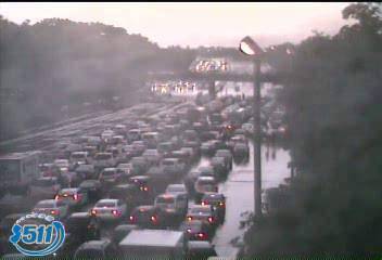
Today's jackpot precip winner just might be the Philly Airport. This afternoon, Philadelphia International airport recorded 7.27 inches of rain that occurred from 3pm-6:44pm,breaking the all-time record for rainfall in a single day. Route 42 in Southern New Jersey, which is a major roadway between NJ and Pa was shut down due to flooding (pictured).
The official rainfall total at Philly Airport yesterday was an astounding 8.02 inches. A new record for 7/28, the month and for any day for that matter in their history. Pretty amazing:
http://forecast.weather.gov/product.php?site=NWS&issuedby=PHL&product=RER&format=CI&version=1&glossary=0
That really is amazing Vic. If it were a normal commuting day there probably would have been some big problems. Kind of like what happened in Toronto last month.
the weather has been so lovely, why are there going to be thunderstorms...thought they developed when it is really hot or a cold front is coming through?
Tomorrow's storms will be because of an approaching cold front. Normal to slightly below normal temps will be the rule, mainly because there have been an unusual number of cold fronts dropping down out of Canada lately (I can hear GC clapping in the background lol).
Wow thanks Bryan, get it..Was enjoying the weather this week and did not think that temps could get lower...Def appreciate the cold front dropping down from Canada..Sorry Christine that you are missing the heat, and GC you are a poet!! Or maybe paraphrasing a Canadian song, smile!
Lots of rain this morning! Maybe a few rumbles of thunder. It will taper down this afternoon and end by evening with cooler weather on the way and a nice stretch of days coming up after today.
A picture is worth a thousand words - http://www.meteo.psu.edu/~fxg1/WXTYPE/loop25ne.html
No more cooler weather! We're supposed to be heading out to LI for a beach vacation and 70's is not what I was hoping for.
This summer is just a bust:(
Another crazy weather day (Tues 8/13) mostly for the South Jersey shore with a ton of rain and a confirmed tornado around 10 AM in Manahawkin:
http://www.newsworks.org/index.php/down-the-shore/item/58540-manahawkin-resident-describes-tornado-as-qterrifyingq
We were able to squeeze out a general inch to inch a half between the morning's and evening's precip. Thankfully nothing severe up in this part of the State.
Yeah about an inch here at the north end of Lake Hopatcong. The cool weather (for August standards) looks to continue for the next week. Taking a peak at the models it looks to me like some warmer weather gets here by later next week or so. We'll see how it pans out by then.
So our warmup really only lasted a day. Now we are looking at near normal temps. However a heat wave looks to build next week in the central US and probalby the southeast which hasn't had a hot summer at all. We will be on the edge of this. That basically means a warmup but nothing crazy. T-storms like to ride along the edges of heat waves so that could put us in the line of fire next week for some decent storms. It's really been quiet this summer in that deptartment so we'll see if that changes next week.
I don't want more blazing temps but I'm really tired of this constant damp weather. It's not hot enough for my A/C to kick in consistently so it always feels really humid. Nothing is dried out and moss everywhere. Is this what London and Seattle is like?
I cannot say anything about summer in London and Seattle but we had the same temperature as Moscow (even colder at nights) plus high humidity. My family took a walk in the local park last week and we found a lot of Chanterelles and other edible mushrooms. It's a first time I found them here, even not going to High Point State park. And it's not September or October yet. Hope we will not get first freeze in September.
Nothing at all like London or Seattle. The cold really creeps in London. Seattle is a constant mist. I don't think you'd particularly like Charleston either - another different kind of constant dripping wet.
 H-town Mama
 happened to be at A&P around 8pm tonight and the lightning show was fantastic. All over the sky dancing lightning. A little thunder in the background and no rain. I stayed there in the car for about 20 minutes watching. beautiful.
Could be a quick burst of severe weather in the area within the hour as some storms associated with the cold front move through our area. NWS just posted a Severe Thunderstorm Warning until 12:30 this morning. Make sure those windows are closed!
http://forecast.weather.gov/showsigwx.php?warnzone=NJZ007&warncounty=NJC041&firewxzone=NJZ007&local_place1=&product1=Severe+Thunderstorm+Warning#.UiVZujaTh5E
Yeh worst sounding storm of the summer moved through Lk Hopatcong around 12:30 am. Not a ton of rain but very loud thunder/lightning.
Windows stayed wide open to watch the lightning storm. Very little rain over night. Beautiful!
Very little rain here as well (0.06) as the storm passed to my north. It basically rode Route 80 after it entered NJ before fizzling out over Bergen County. Thankfully no reports of any damage this morning as far as I can tell.
No damage that I've seen, but we did seem to get a bit more water than that. It wasn't that much though, the real event was the lightening display. Kept poor Sugar under the bed hiding all night long.
So now that all that humidity is gone maybe it's about time to start a Fall weather thread. We are finally getting a really nice stretch of weather. It feels like we waited all summer for this. Now it will come without the heat though. By Thurs night most areas will be way down in the 40s and i'm sure there will be some 30s. Eventually by Sunday and beyond we should warm back up to at least normal though.
leaving tomorrow to tent camp at Arcadia National Park first time camping by myself. will have chilly mornings and nights. weather looks good.
I swear Bryan it feels like winter here in the overnight early morning time (I'm just outside of Walpack in Sandyston). It warms up nicely during the day but cold once the sun goes down.
I believe it M&K. That Sandyston area gets pretty chilly at night. It's a good radiational cooling spot.
Bryan, what kind of weather are we looking at for the rest of the month, in your opinion?
Temps never hit 90 degrees locally during the month of August. Which is really something. Pequest got to 87 multiple times during the month and Hackettstown could only make it as high as 85. With that said, here's a little weather trivia courtesy of our NWS office in Mt Holly:
This past August was the first time since 1984 that Philadelphia did not hit 90 degrees. We are expecting the high temperature on Wednesday to reach 90 degrees. When was the last time that Philadelphia did not hit 90 degrees in August, but did so in September?
Scroll down for answer
.
.
.
.
.
.
.
.
.
.
.
.
.
.
1927!
Tracy I see this month being a bit of a roller coaster. We should have those occasional warmer days thrown in the mix (mid to upper 80s Weds) along with cooler days like this past Friday and this Monday. The big thing is it looks like it's going to be on the dry side. This Thursday will bring us a good chance of showers/storms though.
Thanks, Bryan! I'm just hoping to not be miserable for the remainder of this pregnancy. This past weekend was such a relief after the horrible humidity and high dew points we had last week. I can take the warmer temps better without all that.
Strange T-storm in Hunterdon Co. this morning. It kind of just sat in the same spot for quite a bit, then moved to the west.
I'm on the mountain in LV and we've been hearing the booms for a long time now. Weird storm indeed.
Loud and long thunder in Pburg - set off car alarms in Walmart parking lot - Bright lightening too.
wendy
 wbeleno
 There are a few storms around this morning but they are all south of route 80. The most widespread storms will be this afternoon into evening. A few of them will be strong and they may 'train' over the same area like we're seeing this morning.
Holy -------- ---- the last lightning strike was a direct hit on our house. I almost had a heart attack the noise was so loud. The animals jumped about three feet into the air. Thank G-d for the lightening rod!
Wow Rebecka! Did you get a picture? ;-P
I probably would have needed a change of underwear. The thunder is insane right now. Windows are shaking.
I thought that the storms were not coming till later this afternoon...sheesh the thunder is loud!! Glad you have that rod Rebecka and it kept you safe...Pouring and lots of lightning!
Lightening hit the control tower at BWI International Airport this afternoon and shut down the airport.
WOW! A heck of a storm came through my neck of the woods about an hour ago. Lightning, thunder and super dooper winds! I can't believe my power is still on. Starting to kick up again now.
Just returning from dinner at Louigi's in Belvidere and it took us almost a hour to get home. Two large trees down in the highway on 46...at different locations. The worse part of it happened while we were in the restaurant having dinner and it looked like the place was going to blow away plus all the lightening and thunder. Be safe out there everyone...
Power out for about 45 Minutes in panther valley.
Power just went out on rt 46 in Independence by Hope roads maybe 5 mins ago.
Catswamp road is a mess with multiple trees down. You can barely squeeze by one of the trees that fell on the Allamuchy portion of the roadway. I would imagine they'll close the roadway overnight and begin clearing the road tomorrow morning.
As of an hour ago 517 was closed north of 80, south of Tranquility. Maple Lane closed N of Johnsonburg. Quaker Road closed. Took me 2 1/2 hours to get home from Sussex because of downed trees.
So it looks like the cold front later today should bring some steady rain and a few t-storms can't be ruled out. We are in the slight risk category for severe storms. Some of this moisture is indirectly related to Karen but the bulk of that is staying a bit south. However the actual low pressure center of Karen may redevelop once it gets off the Atlantic coast later in the week. We'll have to keep an eye on that.
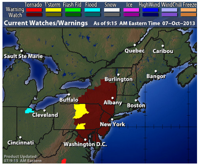
NOAA posted a Tornado Watch for our area:
Tornado Watch in effect from October 7, 09:00 AM EDT until October 7, 05:00 PM EDT
The National Weather Service Has Issued Tornado Watch 543 In
Effect Until 5 Pm Edt This Afternoon For The Following Areas
In Delaware This Watch Includes 3 Counties
In Maryland This Watch Includes 5 Counties
In Pennsylvania This Watch Includes 10 Counties
In New Jersey This Watch Includes 16 Counties
In Central New Jersey
Mercer Monmouth
In Northern New Jersey
Hunterdon Middlesex Morris Somerset Sussex
Warren
In Southern New Jersey
Atlantic Burlington Camden Cape May Cumberland
Gloucester Ocean Salem
Calico that is definitely one of the coolest weather maps I've ever seen! Thanks for posting!!
Basically any time now. Some areas are getting hit now. The line is a bit more broken now so i wouldn't say everyone will get hit hard.
Your welcome. I love that map.
Anyway, the first responder site is showing info of trees and wires coming down out there in WC.
http://www.wcpublicsafety.com/firstresponder/wc911/recframe.html
Had a wind gust this afternoon to 29mph and 0.54" of rain here at my weather station in Hackettstown. Thank god we lost the humidity.
I hear ya KMC concerning the humidity, it was starting to get ridiculous considering the time of year it is.
Thankfully no real reports of damage here in Warren County with yesterday's cold frontal passage though areas of far eastern Morris (Parsippany) into Passaic and Bergen Counties didn't fair as well with numerous trees/power lines down.
Pequest Fish Hatchery yesterday down the road from my backyard reported a 35 MPH wind gust around 3PM. 0.54 was reported in the bucket.
There's still 3,000 out of power, mostly in Monmouth. We got lucky. A little harder or longer and I think things would have started popping.
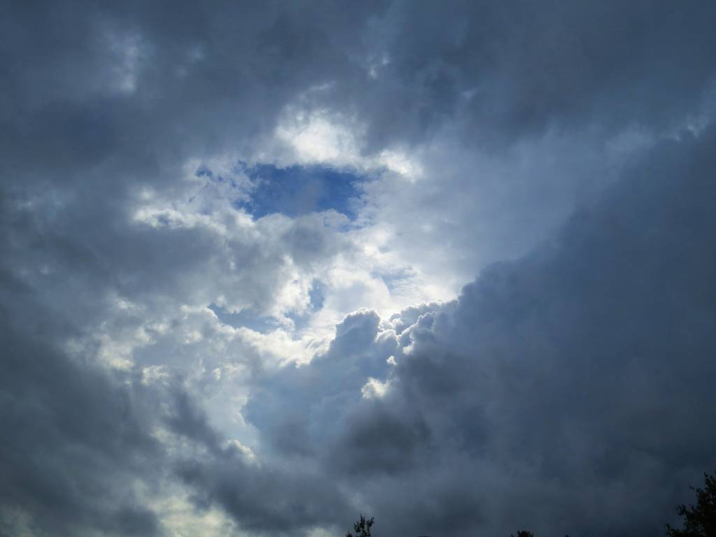
Just as yesterdays storm approached a small hole in the cloud lit up the side of the thunderhead. I thought I'd share.

Here is the latest NWS briefing package concerning the coastal event Bryan alluded to yesterday. Doesn't look like too big of an event for us. Let's see how things trend in the days ahead.
http://www.erh.noaa.gov/phi/briefing/packages/current_briefing.pdf
I'm glad this isn't a snowstorm because it's too close to call still. There will be a pretty good storm off the coast but the high over NE will be blocking it from really coming up the coast. Where the battle line sets up will determine how much wind swept rain we get. It will be a slow mover too so that whether any rain makes it here or not, the coast is going to see some erosion.
blocking ... battle line .... BOOM ... sounds like John Madden analyzing a football play. LOL
Hackettstown Weather Works is predicting snow in late Oct, or early Nov. Lets hope not.
So far this storm isn't living up to expectations which is fine with me. Although i'd take some heavier rain over this dreary mist. I would basically expect showers to continue through tomorrow. A few heavier showers are possible as the storm gets closer. Our weekend will depend on the winner of the battle between the HP in NE and the storm off the coast. Maybe we'll have a better idea by tomorrow.
 happy2bhere
 Old Man Winter is saving all of this year's snow for Super Bowl Sunday.
Then he'll dump a record-breaker of a blizzard on Met Life Stadium.
By the time they dig it out and play the Super Bowl it will be March.
Well, seriously, February usually has been a snowy month in years when there was not much snow in December and January.
The bulk of the rain is staying just south (south jersey/Philly). We shouldn't see more than some drizzle and a spotty shower today and tomorrow. Not a great weekend but for the most part just mainly cloudy with some drizzle here and there. I'm hopeful the sky will brighten a little Sat and Sun PM.
PA has been getting a good soaking...widespread 4-5 inch rainfall amounts with over 6 inches at Harrisburg Airport as of 6:30 AM this morning and it's still coming down with the rain slowly training over those same areas.
http://forecast.weather.gov/product.php?site=NWS&issuedby=CTP&product=PNS&format=CI&version=1&glossary=1&highlight=off\
yeah i think H-burg is up over 7 now. The models didn't do too well with this. That being said it wouldn't have taken much for that rain to be over our area.
The trend is our friend. Looking at the most recent forecasts for the weekend it's more partly cloudy than cloudy. I haven't checked anything but I guess more dry air is pushing in.
True Bryan all this could have easily been over our area. I just looked again at that link above I posted earlier this morning. They just updated some rainfall totals for PA with some 8 to10 inch amounts now.....incredible. We sure dodged a bullet!
Commenting is no longer available.